
UAV/drone surveying

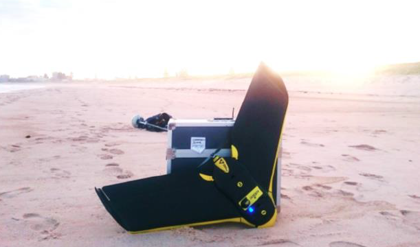
The Water Research Laboratory has developed the expertise, qualifications and equipment range to now provide a professional UAV monitoring service for a wide range of engineering and scientific applications. Our fleet of UAVs includes a fixed wing SenseFly eBee RTK for projects requiring survey grade elevation data, a Vulcan Octocopter with an integrated LiDAR unit for high density surveying and a smaller DJI Phantom 3 Quadcopter with HD video camera suitable for visual aerial monitoring and inspections. Combined with our suite of RTK-GPS equipment, our UAVs provide an innovative and cost effective method to collect high quality survey grade elevation data, high resolution ortho-rectified aerial photography and high definition aerial video data, even in remote areas.
All UAV deployments undertaken by WRL are carried out by one of our Civil Aviation Safety Authority (CASA) approved pilots, who ensures that every UAV survey is conducted in a safe manner that complies with professional flight regulations. Within Australia, WRL have pioneered the use of UAVs for monitoring in the coastal zone, and have now published summary papers to provide an overview and demonstrate the accuracy achieved with the UAV survey methods. We have undertaken numerous scientific surveys that have included analysis of beach erosion, high resolution mapping of breakwater and revetment structures, monitoring of emergency coastal protection works, estuarine vegetation mapping and wetland monitoring. These applied projects have proven the effective use of UAVs as a cost-effective survey tool that provides an alternative method of collecting aerial photography, videography and geospatial data.WRL is leading the way in combining large scale physical facilities, state-of-the-art instrumentation and hydraulic expertise to advance the fundamental understanding of high-velocity free-surface flows and to provide practical design guidelines for the water engineering profession. Due to limitations in numerical modelling of complex flow phenomena, physical modelling remains the most reliable method to test concept and detailed design of hydraulic structures.
-
In addition to providing general surveying and monitoring services, WRL provides a turn-key solution by leveraging our core technical expertise to interpret recorded data. WRL’s engineers and scientists have the skill set and track record to analyse survey data for a wide range of coastal, environmental and hydraulic engineering requirements.
-
- Topographical elevation mapping
- Post disaster mapping
- Disaster response planning/guidance
- Asset inspection and mapping
- Aerial surveillance
- Monitoring of beaches, estuaries, wetlands
- Breakwater/seawall monitoring
- Vegetation mapping
- Dam inspections
- Tower inspections
- Cliff stability analysis
- Aerial photography & cinematography

-
Type: Fixed wing UAV
Wingspan & weight: 96 cm, 700 g
Propulsion: 160 W brushless DC motor
Max flight time: 40 mins
Cruise speed: 40-90 km/h
Wind resistance: Up to 25 knots (45 km/hr)
Coverage per flight: Up to 1 km2
Capabilities:
- RGB camera & Near Infrared (NIR) camera
- RTK GPS receiver
- Inertial measurement unit
- Pitot probe
- Optical ground sensor
- Autonomous flight through built in auto pilot
- Ortho-rectified aerial images with a resolution of 3 cm/pixel
- NDVI maps to assess vegetation health
- Dense point cloud comprising millions of points
- Google Earth overlays of the data
- Data visualisation via fly-through videos
-
Type: Quadcopter UAV
Diagonal dimension: 59 cm
Weight: 1,280 g
Max flight time: 23 mins
Cruise speed: 58 km/h
Wind resistance: Up to 35 km/hr
Hover accuracy: +/-0.1 m vertical, +/-1.5 m horizontal
Coverage per flight: Up to 0.5 km2
Capabilities:- 12.4 M camera
- 2.7 K video camera
- 3 axis gimbal for image stabilisation
- Live video streaming
- GPS/GLONASS receiver
- Ultrasonic ground sensor
- Manual & auto flight modes
