Problem statement
The underground infrastructure is a very complex and heterogeneous system with many different functions, owners and users. The information about underground infrastructure is:
- hosted by many private and governmental agencies
- managed in dedicated software packages.
The agencies are concerned with the capacity, performance, safety, reliability and so on of their own assets only. Sharing of information is limited and difficult and becomes a great disadvantage when subsystems are interfering with each other.
Lack of information about underground assets and their links with above-ground facilities leads to failures, delayed construction works and extra costs.
Solutions
We propose an innovative mechanism for information exchange of underground infrastructure, which will ensure interoperability and security. The intended integrated information management approach will:
- provide information, which will be sufficient only to indicate locations of underground assets to support only operations such as repair and maintenance, or design of new infrastructure, or unexpected events, such as accidents, natural disasters and attacks
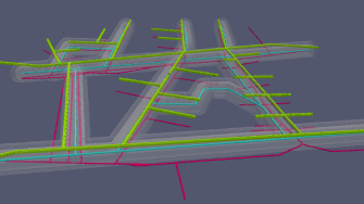
- be through virtual data model consisting of underground components and their 3D geospatial representation and properties, which are of benefit for all involved stakeholders and agencies
- be based upon state-of-the-art technology, open standards and best practices.
Outcomes
The value of the proposed solution is in manyfold. It will ensure that the dedicated information systems that are being used by the respective agencies will remain unchanged. It will:
- provide a robust way to share information while hiding sensitive parameters about the assets, being based on well-known standards
- allow straightforward integration of data in commercial packages or web-based implementations
- ensure flexibility in representing assets and their components as vector or raster environments to support complex analysis.
