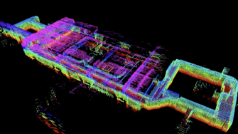
Description
This pilot, sponsored by the Public Safety Communications Research Division of NIST, will create and advance solutions to complex geospatial challenges related to indoor mapping and navigation for first responders.
Main concept
The focus of the pilot is on developing the capabilities and workflow required for preplanning operations. The intent is that future OGC initiatives will address the real-time, event-driven aspects of indoor mapping and navigation for first responders. To accelerate research and development for this public-safety-driven scenario, this initiative will conduct the following prototyping and demonstration activities:
- Create and convert 3D indoor LiDAR point cloud models and associated imagery to functional building and navigation models.
- Store and serve point cloud, building and navigation models for visualization and navigation.
- Derive dynamic turn-by-turn indoor navigation instructions based on the navigation model.
- View and annotate point cloud data, imagery and building models, along with navigation routes and instructions into, through and out of buildings.
For more information please visit here.
People involved
| Participant’s details | Organisation |
|---|---|
| Prof. Sisi Zlatanova | UNSW, Built Environment, GRID |
| Prof. Ki-Joune Li | Pusan National University |
| Dr Abdoulaye Diakite | UNSW, Built Environment, GRID |
| Mitko Aleksandrov | UNSW, Built Environment, GRID |
