This month we’ve seen some crazy, devastating weather. Perth recorded its wettest July in decades, with 18 straight days of relentless rain. Overseas, parts of Europe and China have endured extensive flooding, with hundreds of lives lost and hundreds of thousands of people evacuated.
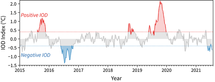
And last week, Australia’s Bureau of Meteorology officially declared there is a negative Indian Ocean Dipole — the first negative event in five years — known for bringing wet weather.
But what even is the Indian Ocean Dipole, and does it matter? Is it to blame for these events?
What is the Indian Ocean Dipole?
The Indian Ocean Dipole, or IOD, is a natural climate phenomenon that influences rainfall patterns around the Indian Ocean, including Australia. It’s brought about by the interactions between the currents along the sea surface and atmospheric circulation.
It can be thought of as the Indian Ocean’s cousin of the better known El Niño and La Niña in the Pacific. Essentially, for most of Australia, El Niño brings dry weather, while La Niña brings wet weather. The IOD has the same impact through its positive and negative phases, respectively.
Positive IODs are associated with an increased chance for dry weather in southern and southeast Australia. The devastating Black Summer bushfires in 2019–20 were linked to an extreme positive IOD, as well as human-caused climate change which exacerbated these conditions.
Negative IODs tend to be less frequent and not as strong as positive IOD events, but can still bring severe climate conditions, such as heavy rainfall and flooding, to parts of Australia.
The Indian Ocean Dipole (IOD) index, used to track the variability of the Indian Ocean Dipole. An event occurs after the index crosses the threshold for 8 weeks. Bureau of Meteorology
The IOD is determined by the differences in sea surface temperature on either side of the Indian Ocean.
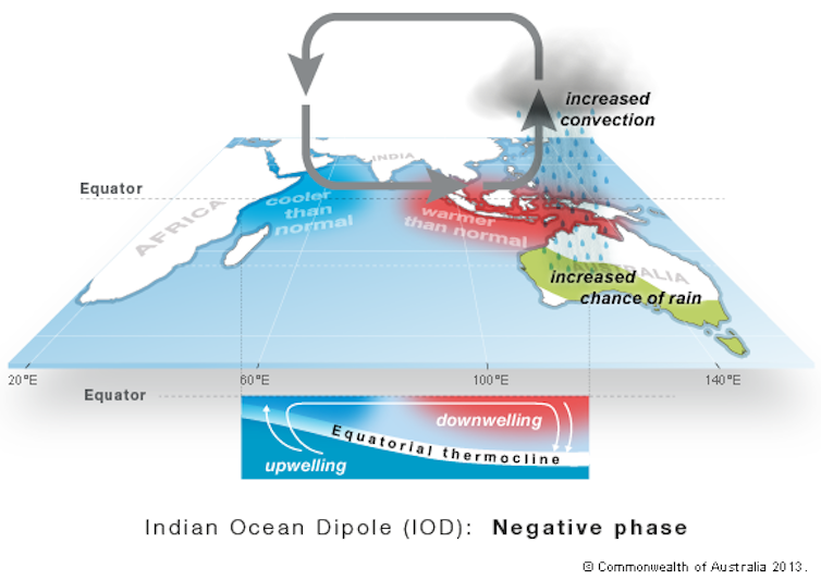
During a negative phase, waters in the eastern Indian Ocean (near Indonesia) are warmer than normal, and the western Indian Ocean (near Africa) are cooler than normal.
Read more: Explainer: El Niño and La Niña
This causes more moisture-filled air to flow towards Australia, favouring wind pattern changes in a way that promotes more rainfall to southern parts of Australia. This includes parts of Western Australia, South Australia, Victoria, NSW and the ACT.
Generally, IOD events start in late autumn or winter, and can last until the end of spring — abruptly ending with the onset of the northern Australian monsoon.
The negative phase of the Indian Ocean Dipole. Bureau of Meteorology
Why should we care?
We probably have a wet few months ahead of us.
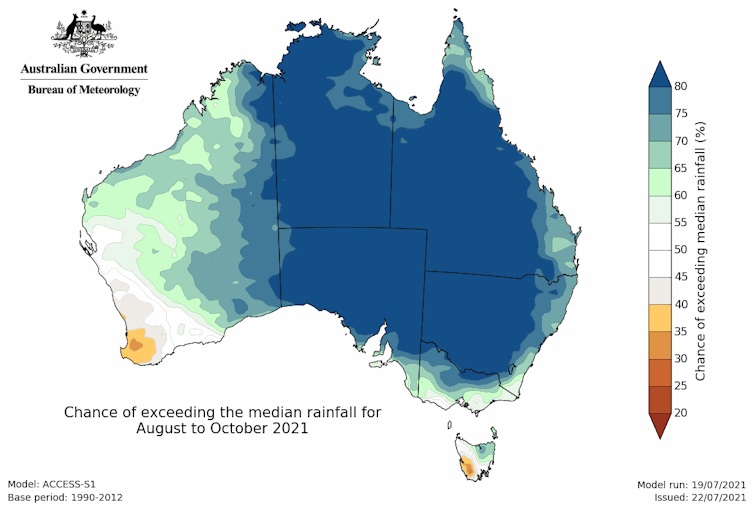
The negative IOD means the southern regions of Australia are likely to have a wet winter and spring. Indeed, the seasonal outlook indicates above average rainfall for much of the country in the next three months.
In southern Australia, a negative IOD also means we’re more likely to get cooler daytime temperatures and warmer nights. But just because we’re more likely to have a wetter few months doesn’t mean we necessarily will — every negative IOD event is different.
Rainfall outlooks for August–October suggest that large parts of Australia will likely experience above-median rainfall. Bureau of Meteorology, CC BY
While the prospect of even more rain might dampen some spirits, there are reasons to be happy about this.
First of all, winter rainfall is typically good for farmers growing crops such as grain, and previous negative IOD years have come with record-breaking crop production.
In fact, negative IOD events are so important for Australia that their absence for prolonged periods has been blamed for historical multi-year droughts in the past century over southeast Australia.
Negative IOD years can also bring better snow seasons for Australians. However, the warming trend from human-caused climate change means this signal isn’t as clear as it was in the past.
A negative IOD may mean a better snow season in the High Country. Shutterstock
It’s not all good news
This is the first official negative IOD event since 2016, a year that saw one of the strongest negative IOD events on record. It resulted in Australia’s second wettest winter on record and flooding in parts of NSW, Victoria, and South Australia.
The 2016 event was also linked to devastating drought in East Africa on the other side of the Indian Ocean, and heavy rainfall in Indonesia.
Thankfully, current forecasts indicate the negative IOD will be a little milder this time, so we hopefully won’t see any devastating events.
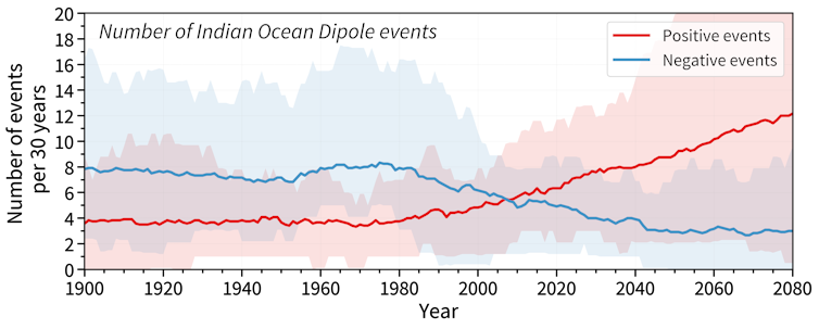
The number of Indian Ocean Dipole events (per 30 years) based on climate models. Modified from Abram et al. (2020)
Is the negative IOD behind the recent wet weather?
It’s too early to tell, but most likely not.
While Perth is experiencing one of its wettest Julys on record, the southwest WA region has historically been weakly influenced by negative IODs.
Negative IODs tend to be associated with moist air flow and lower atmospheric pressure further north and east than Perth, such as Geraldton to Port Hedland.
Outside of Australia, there has been extensive flooding in China and across Germany, Belgium, and The Netherlands.
It’s still early days and more research is needed, but these events look like they might be linked to the Northern Hemisphere’s atmospheric jet stream, rather than the negative IOD.
The jet stream is like a narrow river of strong winds high up in the atmosphere, formed when cool and hot air meet. Changes in this jet stream can lead to extreme weather.
What about climate change?
The IOD — as well as El Niño and La Niña — are natural climate phenomena, and have been occurring for thousands of years, before humans started burning fossil fuels. But that doesn’t mean climate change today isn’t having an effect on the IOD.
Read more: Why drought-busting rain depends on the tropical oceans
Scientific research is showing positive IODs — linked to drier conditions in eastern Australia — have become more common. And this is linked to human-caused climate change influencing ocean temperatures.
Climate models also suggest we may experience more positive IOD events in future, including increased chances of bushfires and drought in Australia, and fewer negative IOD events. This may mean we experience more droughts and less “drought-breaking” rains, but the jury’s still out.
When it comes to the recent, devastating floods overseas, scientists are still assessing how much of a role climate change played.
But in any case, we do know one thing for sure: rising global temperatures from climate change will cause more frequent and severe extreme events, including the short-duration heavy rainfalls associated with flooding, and heatwaves.
To avoid worse disasters in our future, we need to cut emissions drastically and urgently.
Read more: You may have heard the 'moon wobble' will intensify coastal floods. Well, here's what that means for Australia
Nicky Wright, Research Fellow, University of Sydney; Andréa S. Taschetto, Associate Professor, UNSW, and Andrew King, ARC DECRA fellow, The University of Melbourne
This article is republished from The Conversation under a Creative Commons license. Read the original article.