Synopsis
Vegetation cover is routinely monitored across Australia using imagery from the Landsat and Sentinel-2 satellites and a fractional vegetation cover model based on field measurements. Although the model is extremely useful, it doesn’t differentiate between different vegetation structural forms, such as grasses, forbs, shrubs and trees.
Arid zone vegetation is often a mix of grasses and forbs that fluctuate rapidly in response to rainfall and grazing and more persistent slower growing shrubs and trees. It may be possible to develop a new model that separates the structural forms based on analysing a time series of vegetation cover images.
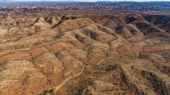
High-resolution drone imagery collected in 2016 at Fowlers Gap Arid Zone Research Centre is available for calibration and validation of the new model, and there is the possibility of conducting fieldwork to collect new data. There is also the potential to collaborate with NSW government scientists who use drone and satellite imagery to monitor vegetation across the state.
Aims
To develop a model of shrub cover at Fowlers Gap using a time series of satellite imagery and drone imagery. This requires learning many procedures common to remote sensing research.
You’ll develop skills in the following areas:
- exploration of data
- development of statistical models
- assessment of the resulting maps.
Student benefits
This is an applied remote sensing project that will allow the student to develop skills in quantitative geography and analysing large data sets. The results will be of interest to the NSW and QLD governments, who map and monitor vegetation cover using satellite imagery. Experience in remote sensing and GIS is essential, and some knowledge of using a scientific programming language such as Python is desirable.
Get involved
To learn more about this project, contact Dr Adrian Fisher and A/Prof. Shawn Laffan
E: adrian.fisher@unsw.edu.au
T: +61 2 9385 3393
E: shawn.laffan@unsw.edu.au
T: +61 2 9385 8093
