Change detection in remotely sensed images
Published on the 29 Nov 2018 by Penny Jones

Part of the inspiration for this research was drawn from a recent sabbatical in India where Professor Arcot Sowmya spent six months working in a large Indian multinational software consultancy firm. Change detection was something they asked her to develop some ideas around, so she did a preliminary literature review and got really interested in taking the field further.
“When Matt approached me to discuss PhD options around computer vision and deep learning, I thought combining them with ideas around change detection in remote sensing would be a fascinating area to pursue. As a growing area of interest this capability has significant and wide-ranging applications,” she explains.
Research on change detection in remotely sensed images (from satellites, aircraft and drones etc) has its roots in surveying and photogrammetry for land use planning, but over time the technology has improved exponentially, along with the quality and quantity of remotely sensed images.
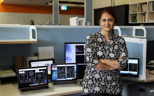
“Now, the capacity for generating remotely sensed imagery far exceeds the capacity for visual change analysis by humans so automating these cognitive and perceptual tasks is necessary if the data is to be usefully applied. It’s just not something that can be manually attempted anymore,” continues Matthew Gibson, PhD candidate, UNSW Computer Science Engineering.
According to Gibson, the automatic assessment of things like building damage following natural disasters has been attempted across a variety of platforms from UAV (unmanned aerial vehicle) to satellite, and with different modalities such as optical and SAR (synthetic-aperture radar) imagery.
“There have been many studies to automate the assessment of natural disasters such as earthquakes and floods using machine learning and computer vision techniques,” Gibson says.
“These techniques are useful because they can supplement traditional techniques such as ground-based field surveys, which can be slow and dangerous for personnel, and provide a rapid response that is an essential part of disaster management.”
Gibson started his PhD 18 months ago and says for the purposes of his research he and Sowmya decided that automatic change detection for bushfires would be a good area of focus. Now, under the joint supervision of Sowmya and his PhD co-supervisor Emeritus Professor John Trinder from UNSW Civil Engineering he is making good progress.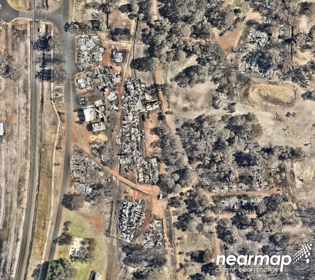
“I started by sourcing pairs of ‘before’ and ‘after’ images of bushfire affected areas from a pre-existing catalogue of imagery by Nearmap (a company who do repetitive image capture over 80-90% of Australia’s populated areas),” says Gibson.
“Then we recruited about 40 crowd-workers who used a custom-built data collection tool to perform ‘annotations’ on about 200 remotely sensed images. We asked them to pinpoint the area of interest in the ‘before’ image and the damage caused by the bushfire in the ‘after’ image,” he continues.
According to Sowmya, crowdsourcing data collection (in this case through Amazon Web Services) is a fairly novel way to collect data for the analysis of remotely sensed images.
“Crowdsourcing is a great way to generate labels for images or regions of images as quickly as possible. Then, by using these examples, we can train algorithms to find visual changes automatically,” she explains.
So far, Gibson has developed a dataset and an object detection model for the rapid identification of collapsed buildings in bushfire impacted areas from aerial imagery, but says the end point of this research would be the creation of software that could run constantly in the background on pairs of images, automatically detecting and reporting change.
Although automatic change detection through remote sensing is still in its infancy, Sowmya and Gibson say there are multiple industries that would be interested in the type of technology they are creating. These include insurance, agriculture, disaster response and recovery, environmental monitoring and conservation, facilities management, land-use mapping, coastal erosion, and defence.
“It would be useful anywhere you want to detect change and require precise measurements in terms of area, volume and actual location on the ground. It could also be trained to detect changes in different datasets and tuned to work with any new object of interest,” says Gibson.
Sowmya continues: “There are layers of interest coming from different fields and it will only increase in importance, given Australia’s developing space interest and through institutions like Geoscience Australia. We are working to complement what the civil engineers do, and I can envisage a big industry being created locally, given that Australia already has a niche capability in the imaging area.”
//