Beach erosion: satellites reveal how climate cycles impact coastlines
New research shows coastlines across the Pacific Ocean may respond differently to El Niño and La Niña cycles.
Published on the 10 Feb 2023 by Ben Knight

New research shows coastlines across the Pacific Ocean may respond differently to El Niño and La Niña cycles.
Researchers from UNSW Sydney have analysed millions of satellite photos to observe changes in beaches across the Pacific Ocean. The findings, published in Nature Geoscience today, reveal for the first time how coastlines respond to different phases of the El-Niño-Southern Oscillation (ENSO) cycle.
ENSO is a natural climate phenomenon that causes variations in sea surface temperatures over the Pacific Ocean. The warming phase, known as El Niño, and the cooling phase, known as La Niña, affect weather patterns across different coastlines depending on the cycle.
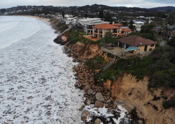
During these periods, coastal erosion can also intensify, shifting sand away from beaches and threatening beachfront homes and habitats. But scientists haven’t been able to study this broadly using conventional coastal monitoring techniques, which have been limited to on-ground observations on just a few beaches.
“Scientists have known beaches respond to ENSO cycles for decades, but we’ve only been able to paint a small picture of this from a few sporadic beach monitoring sites,” says Dr Mitchell Harley, co-author of the study from UNSW’s Water Research Laboratory at the School of Civil & Environmental Engineering. “For this research, we were able to take a completely different angle to complete the bigger picture of how climate cycles impact entire Pacific coasts.”
Satellites orbiting the Earth have captured images of the world’s coastlines at regular intervals for almost forty years. The researchers developed a new open-source tool called CoastSat, which combines image processing and machine learning algorithms to extract information from every pixel about thousands of sandy beaches along the Pacific rim.
“The tool automatically maps the position of the interface between the sand and water. Doing this over multiple images and beaches, and correcting for the tide, we can discover changes in the coastline over a large temporal and spatial scale and how this correlates with ENSO cycles,” says Dr Kilian Vos, lead author of the study from the Water Research Laboratory.
Using the tool, the researchers processed 38 years of Landsat satellite photos to find correlations in beach width and El Niño and La Niña cycles across more than 8000km of sandy coastline, from the east coast of Australia to the west coast of California and down to Chile.
They found that beaches on the southeast coast of Australia narrow during prolonged La Niña, while they widen – or accrete – during El Niño periods. But beaches on the other side of the Pacific experience the opposite effect – eroding during El Nino and recovering during La Niña.
“While our study is looking at the average behaviour of sandy beaches correlated with the ENSO cycle, this is consistent with what we’ve observed, for example, with the recent triple-dip La Niña in Australia, where successive coastal storms have been stripping sand from beaches along the NSW and QLD coastlines,” says Dr Vos.
The researchers say understanding the impact of ENSO cycles on different coasts of the Pacific can help coastal managers and residents anticipate coastal erosion risks and prepare with protection measures like beach nourishment.
“Sandy coasts are some of the most dynamic and populated environments on the planet. In some conditions, they can completely disappear overnight and take years to come back,” Dr Vos says.
“It’s essential we continue to monitor them through studies like this which help inform how we can manage our beaches, which provide a buffer between ocean waves and the high-value infrastructure around them.

The study can help coastal managers and residents anticipate coastal erosion risks. Photo: Water Research Laboratory.
“If you’re a tourist looking to spend a holiday on the beach, it might be worth looking at the ENSO forecast as it might give you an indication of where to expect wide sandy beaches.”
Dr Harley also leads the CoastSnap citizen science project, where community members share their shoreline photos to create new insights into how beaches respond to changing conditions.
Read more: How the power of social media is helping coastal areas deal with the power of extreme storms
The researchers plan to further analyse the data from both projects to uncover insights on how beaches respond to waves, sea levels and climate change as close to real-time as possible.
“Some studies suggest climate change will alter ENSO patterns, which may affect how coastlines change further, in terms of intensification of these erosion and accretion effects, or a shift in where they occur,” Dr Harley.
“Using all these incredible data sources from space and the community, we can continue to increase our understanding of how our coastlines are changing now and in the future.”