Low level aerial survey work will be carried out by the University of NSW from 1st October to 15th November 2024, over areas of eastern Australia indicated in the map below.
The work is part of a collaborative large scale wildlife monitoring program designed by CSIRO that has operated successfully since 1983 and is supported by the Australian, Queensland, New South Wales, Victorian and South Australian governments.
For a detailed look at the aerial survey areas, please use the interactive map linked below.
Aerial surveys are recognised as an efficient, cost effective monitoring tool for wildlife management (e.g. kangaroos, waterbirds) and pest species monitoring (pigs, buffalo, goats) and are widely used throughout Australia
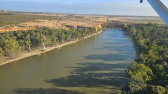
The work involves surveying waterbirds during daylight hours over waterbodies down to 150ft at an operating speed of around 110-130 knots. The aircraft is a single engine Cessna Caravan with an experienced pilot and crew. The pilot has CASA certification to operate these specialised low level flights. The aircraft remains at low level over water only as long as necessary for wildlife experts to conduct waterbird identification and counts, usually less than 2-3 minutes in any given location.
The aircraft operates mainly over water, usually doing a circuit around larger waterbodies, swamps, reservoirs, or along creeks, rivers and watercourses. We fly above 1000 ft over built-up areas, and above 500 ft over dwellings, buildings or locations where we can identify that stock operations are in progress.
Further information on aerial survey of waterbirds including blogs with video from previous years' surveys can be found here.
If you would like further information or have any concerns please contact us at ecosystem@unsw.edu.au