Date: Tuesday, November 14, 2017
Project: Eastern Australian Waterbird Survey
Just a few more days of aerial survey for 2017 – we’re all looking forward to the 35th year finishing. From Sydney, we headed straight for Moree and the Gwydir wetlands, one of the more important wetlands in the Murray-Darling Basin.
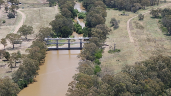
Over the Hawkesbury River on our way to Moree and the Gwydir wetlands
After refuelling at Moree, we surveyed the southern part of the Gwydir river system, the Meehi River and Mallowa Creek.
Surveying the lagoons along the Mallowa Creek.
Here much of the riparian vegetation had been cleared with cropping now abutting these wetlands. This means environmental flows, which once spread out onto the wetlands, often now floods crops. If we are going to maximise the benefits of flows for the environment, then these environmental flows should be able to go where they naturally once went. This means working out with landholders whether easements or opportunities to flood can work.
Patchy crops reflect the poor rainfall and low nutrient soils along the Meehi River and Mallowa Creek.
Most of the large storages for cotton irrigation out here were either dry or drying, a reminder of how much drier the north of the Murray-Darling Basin, compared to the south this year.
Surveying the lagoons at the end of the Gwydir River system, near Collymongle.
There wasn’t much in the way of water along this system – none of the floodouts where the birds had congregated in the past were present. We then worked our way north and back east along the major wetlands of the Gwydir River system.
Along the way, west of the Gwydir wetlands, there was a tell-tale sign of paddocks cleared of their ‘lonely’ trees, tidying them up for large scale farming.
The ecological evidence has shown unequivocally that these single trees are crucial in terms of connecting the birds and other animals to patches of native vegetation. These animals also feed on pests in agricultural land.
Not far from here we joined the most westerly part of the Gingham Watercourse, one of the last major wetland areas in the Gwydir River system.
The first wetlands of this system were dry.
The long green floodplain showed where water had been and it wasn’t long before we found patches of water on the floodplain, considerably smaller than last year. These floodplains used to be extensive but are now confined by agriculture. As we headed east, the reedbeds were taller and patches of water started to appear in the Gingham watercourse.
The remaining reed beds were tall with only a few patches of water among the wetlands of the Gingham watercourses.
These patches of water still had a high diversity of waterbirds. It was great to see a couple of black-necked storks or jabirus and two flocks of 20 brolgas in among the black duck, grey teal, egrets and glossy ibis. The numbers were understandably low, compared to when this system flooded last year. We looped around each of the patches of water to flush the waterbirds and get a good count.
Surveying the lagoons along the Gingham Watercourse
We then headed down to the Gwydir watercourse to the south, which was drier and had fewer waterbirds. It was then east on to survey a couple of the creeks and past the more intense agricultural areas where cotton is the main crop.
Crop duster preparing cotton fields for the summer.
Finally, we surveyed a stretch of the Gwydir River leading up to Yarraman Weir, one of the major regulatory structures on the river.
Yarraman Weir on the Gwydir River controls water down here to allow it to be diverted for irrigation and delivered for environmental flows.
