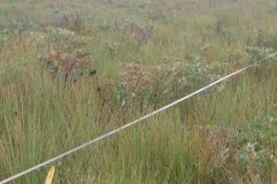
Upland swamps are dynamic and diverse ecosystems that support mosaics of shrub and sedge-dominated plant communities, often within a forested matrix. The spatial configuration of these vegetation mosaics may reflect current and antecedent conditions of hydrology, nutrient availability and disturbance regimes such as fire, as well as interactions between the component species of the system. For research, they offer important opportunities to study how the interaction between environmental gradients and disturbance regimes influence the persistence of biodiversity. This has potential to produce significant advances in theory and practical outcomes for conservation management.
In Australia, several ecological communities within upland swamps are listed as endangered under environmental legislation. Swamps provide specialised habitats for a wide range of native flora and fauna, and important ecosystem services to human communities. In catchment areas, they provide water filtration and flow regulation services – an important function for reliable water supply of urban areas such as Sydney. Further, their carbon sequestration and storage service has yet to be quantified in Australia, but is likely to attain additional importance as climate change intensifies.
The delivery of ecosystem services contributed by swamps is threatened by processes such as underground mining, catchment disturbance and altered fire or sedimentation regimes. There is a very real danger that these ecosystems will be lost or transformed without full cognition of the biotic and abiotic factors which govern their distribution and the ecosystem services they provide.
A research program, led by Professor David Keith and Dr Tanya Mason, is investigating these issues by asking:
How does swamp vegetation respond to environmental drivers such as changing climate or fire disturbance over time? What are the biogeographic relationships across different swamp systems in eastern Australia? What levels of ecosystem services are provided by swamps in the landscape matrix? What is the conservation status of swamps at national and regional scales?
A number of research strands will resolve these questions. In Dharawal National Park, south of Sydney, floristic changes across permanent transects have been monitored periodically since 1983 as part of Australia's Long Term Ecological Research Network. High resolution hydrological monitoring has recently been established across the regional rainfall gradient across which the swamps are distributed. This will improve understanding of the hydrological sensitivity of swamp vegetation. A remote sensing change detection study is monitoring the spatial dynamics of landscape vegetation patterns from the 1940s to present. These show late 20th century expansion of swamps, but recent modelling suggests that their distributions are likely to contract under future climate scenarios. And a biogeographical review is underway to characterise regional variation in swamp systems across eastern Australia.
The work will support conservation planning and management of swamps, improve understanding of regional variation, assess risk status and model distributions with climate change.


