Date: Tuesday, October 20, 2015
Project: Eastern Australian Waterbird Survey
Observer: Richard Kingsford
New blogger on survey today. Terry did a wonderful job surveying and writing about our northern survey. Today we headed northwest out of Sydney, over the magnificent Blue Mountains. They are spectacular from the air, stretching in all directions, their great sandstone cliffs catching the morning light as we flew over. On to the Central West where farm lands are pock marked with small farm dams. Our first survey was over Burrendong Dam near Wellington. This large dam holds more than a million megalitres when full – about two Sydney Harbour’s worth of water. The dam regulates the Macquarie River – the main source of water for the magnificent Macquarie Marshes northwest of the town of Warren. Environmental flows held in dam such as these are really beginning to provide tangible benefits for wetlands and the myriad of organisms that rely on rivers for their livelihoods as well as landholders downstream. Last week the survey saw the benefits of the latest environmental flows from the Macquarie.
Photo 1. The spillway of Burrendong Dam with low water levels
Today the dam is only about 5% providing little water for downstream irrigators or the Macquarie Marshes. The thick ‘arms’ of the dam are usually wide expanses of water sinuously threading their way through the hills but today they resembled ‘threads’ of water woven through the hills. Cormorants and pelicans are usual fare on Burrendong Dam and today was no different. Wood ducks especially like to graze the edges of these large dams as they dry out. Then on along to survey the Macquarie River as it flows towards Dubbo. Today, there were hundreds of straw-necked ibis along the river which was unusual. They rely on the floods and big flows on the rivers such as the Macquarie to breed in spectacularly large colonies in the Macquarie Marshes. The diversion of water upstream has reduced their breeding in the Marshes. There were also a few wood ducks and Pacific black ducks along the river and large flocks of sulphur crested cockatoos, erupting out the trees as we flew past.
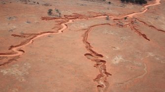
West of Dubbo and on to our final destination of Broken Hill was a long haul even in a small aeroplane. Like the north, it was dry. The green tinge and full dams around Dubbo soon became replaced by dry bush and drying farm dams. Natural wetlands are few and far between, filling only when there is widespread rain. In this dry El Nino year, there was little free-standing water. An eroded gully, probably produced by a large thunderstorm, looked spectacular from on high.
Photo 2. Gully eroded probably by thunderstorm
On the way, we flew over the Tallywalka Creek system, a large system of lakes which receive water and fill when the creek flows during floods in the Darling River. It had water last year but all the lakes were dry this year but green where landholders had planted crops on the lakebed, taking advantage of the natural fertility of these systems and the moisture retained by the soil.
Photo 3. Lakebed cropping on the Tallywalka Creek lakes
Menindee Lakes were mostly dry – a stark contrast to previous years. These lakes are managed with the River Murray to hold water for South Australia. Most were dry. Lake Wetherill is the dam created by Main Weir across the Darling River impounding water which is then diverted into the Menindee Lakes which are used to store water.
Photo 4. Lake Wetherill – the artificial dam made by Main Weir looking very empty
Video 1. The Darling River is impounded by Main Weir but today was almost dry.
Only Lakes Tandure and Pammamaroo had water and were extremly shallow. These lakes hardly have any waterbirds when they are full. Dry lake and constant water in these lakes is not good for their ecology. The two lakes were the most productive they have been for years because the shallow waters make so much food available for the tens of thousands of waterbirds on the lakes. There were thousands of pink-eared ducks, Eurasian coot and grey teal. The lakes looked spectacular with drying patterns creating a crazy paving effect.
Photo 5. Lake Pammamaroo drying out but creating habitat for thousands of waterbirds
Lakes Menindee and Cawndilla were dry
Photo 6. Dry lake bed of Lake Cawndilla on Kinchega National Park
The nearby Darling River was in a poor state – a deep green in the grey landscape, probably reflecting high levels of blue green algae.
Video 2. The Darling River with little water in its channel.
