Date: Thursday, November 5, 2015
Project: Eastern Australian Waterbird Survey
Observer: Richard Kingsford
We just beat the huge storm front which came through Mildura where we stayed last night. We decided to get away early in case we experienced poor weather again but luckily we skirted the edge of another storm front the rest of the day. Today we started our survey at Lock 10 on the River Murray where it meets the Darling River.
Our survey started at Lock 10 across the River Murray, just downstream from where the Darling River comes in at Wentworth.
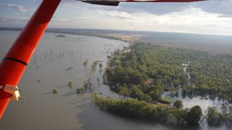
The River Murray was glassy with no wind which makes the plane fly so smoothly. It doesn’t often behave so well. This part of the survey was all the way down the Lindsay-Wallpolla-Chowilla floodplain all the way down to the Ramsar site at Banrock Station, downstream of the town of Berri.
Surveying in the early morning along the River Murray
Along the way we flew along Frenchmans Creek which makes its way into Lake Victoria which is use to store water for downstream use.
Surveying along Frenchmans Creek which flows into Lake Victoria.
Lake Victoria holds water for downstream uses.
There were probably more pelicans and cormorants in the main channel of the river than we normally see, perhaps because it is so dry everywhere. Many of the usually full floodplain billabongs were dry, as were the lakes on the Chowilla floodplain.
Dry lakes on the Chowilla floodplain
There was water in a few of the lakes, including Lake Woolpool which was extremely shallow and had hundreds of pink-eared duck, grey teal, swans and red-necked avocets. The lake was shallow and full of aquatic vegetation, making it highly productive as waterbird habitat.
Surveying Lake Woolpool on the Chowilla floodplain which was shallow with hundreds of waterbirds.
There is increased flows to the Chowilla floodplain as a result of controlled releases of environmental water onto the floodplain through constructed regulators which provide good management control from the River Murray.
Environmental water is controlled and diverted onto the Chowilla floodplain through a series of regulators across one of the distributary creeks.
After we had completed this section of the Murray which had quite a few waterbirds, particularly on the lakes along the river, we continued on to survey the evaporation ponds at Stockyard ponds. These rich saline waters allow aquatic plants to grow and probably also have rich densities of crustaceans. They always provide habitat for hundreds of swans and Eurasian coot. Banded stilts were a surprise to see today as well as red-necked avocets.
We then briefly surveyed a small section of the River Murray, just upstream from where the river reaches the freshwater Lake Alexandrina and Lake Albert.
Surveying the lower River Murray
The rest of the days survey was spent flying around Lakes Alexandrina and Lake Albert, counting them once. They cover a substantial area of water and we had to fly all the inlets to make sure we cover all the waterbirds. This perimeter is about 400 km of shoreline – about two hours of flying.
Our GPS showing our path around Lake Alexandrina and Lake Albert, surveying for waterbirds.
This is always the most exciting part of the River Murray survey because of the incredible numbers of waterbirds of so many different species which depend on these lakes. There were tens of thousands of waterbirds.
Surveying the shoreline of Lake Alexandrina
Lake Alexandrina with it complex shoreline, including reedbeds
There are also at least five colonies of ibis and cormorants breeding on the lake.
Nesting colony of Pied Cormorants on Lake Alexandrina
We stayed in Goolwa overnight and tomorrow we will count the Coorong as well as completing a second count on the two lakes.
