Date: Monday, October 24, 2016
Project: Eastern Australian Waterbird Survey
Observer: Richard Kingsford
Day 14 of our survey was a beautiful one. Not a cloud in the sky and just a breath of wind when we took off from Sydney. Ideal flying conditions. Our survey team was upbeat. Today, we headed south to the bottom of our survey - bands 1 and 2. With the sequence of fronts that had swept over southeastern Australia in the last few weeks, I always got a bit nervous about the weather down south. There’s nothing dangerous. It just throws a real spanner in the works of our logistics when we have to delay because of low cloud. The next three days promised to be ideal – a bonus for surveying the south.
Out of Sydney, we headed for the Avon and Cordeaux Dams, part of Sydney’s water supply. Nestled in the gorges of the Hawkesbury-Nepean River system, these dams are deep with steep sides, not productive wetlands. Despite their large areas, we only saw one swan which was typical.
Surveying Avon Dam, part of Sydney’s water supply
From here, we ‘popped over’ the escarpment, past Port Kembla and down to survey Lake Illawarra, near Woollongong. It is a typical coastal lake with a reasonable complement of black swans and cormorants, the odd royal spoonbill and silver gulls. This was the eastern edge of Band 3 done.
Lake Illawarra, near Wollongong
The mouth of Lake Illawarra
Then on down the beautiful south coast to survey along the eastern part of Band 2 where the swell was impressive.
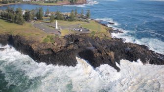
The famous ‘blow-hole’ at Kiama
Flying down the south coast
On Band 2, there are a series of coastal lakes, lagoons and estuaries that we surveyed from Lake Wallaga, near Bermagui, with its few swans.
Surveying an estuary just north of Meribula
From here, we refuelled at the small NSW south coast town of Merimbula before we headed down to start from the eastern end of Band 1.
This was another of those great parts of the survey – 90 mile beach, just east of the Victorian town of Sale. It goes on and on, even though we were in a small plane gobbling up the distance. Here and there is an odd Pacific Gull on the beach. We eventually reach our next survey location.
Ninety mile beach in Victoria
Flying along 90 mile beach
The coastal lakes on the eastern end of Band 1 around the small Victorian town of Seaspray were full for the first time for a long time. Sometimes there can be lots of waterbirds on one of these, Jack Smith Lake, but not today. There were only a handful of ducks but lots of swans nesting. We then surveyed a small section of Corner Inlet where there were a few migratory wading birds but not a lot more.
Surveying the coastal lakes near Seaspray in Victoria.
The section between these lakes and Phillip Island was just farm dams and the odd reservoir – not much to write home about on the waterbird front. Phillip Island, near Rhyll, has a great swamp where ibis sometimes breed in large numbers. There were only a few ibis today. We surveyed a few small wetlands just south of the GP bike track, which was yesterday a hive of activity in the running of the Australian Moto Grand Prix. A wetland lies just next to it with Cape Barren Geese.
Grand Prix motor bike track
Black swans and Cape Barren Geese on a lagoon on Phillip Island
Then on over Torquay and to survey a few dams deep in the Otway Ranges. There was nothing here as usual. We then surveyed farm dams and reservoirs just south of Coolac, until we got to Curdies Inlet on the coast. Here there was just the odd pelican, a lot less than usual.
From here, there are hundreds of small lagoons with mountain duck and all the way into Warrnambool where we stopped for the night.
