Date: Tuesday, October 31, 2017
Project: Eastern Australian Waterbird Survey
Today we headed off on one of my favourite – the flight down the River Murray, starting up near Albury where we had to put on a full tank of fuel for both plane and observers. On the way we flew past Lake George, just north of Canberra and its wind farms.
A half-full Lake George, just north of Canberra, on our way down to Albury.
On the way to our first major wetland survey of the Barmah-Millewa Forest, we surveyed Lake Mulwala which is the is the body of water backed up by Yarrawonga Weir on the River Murray.
Surveying Lake Mulwala on the River Murray which regulates flow for irrigation industries beside the river
Like all large dams, there are few waterbirds relative to the expanse of water but interestingly pelicans breed here in small numbers.
mall colony of pelicans breeding on an island in Lake Mulwala.
Our first major wetland on this leg is the Barmah-Millewa Forest. It is a Ramsar-listed wetland of considerable importance. We quickly have to make a decision when we get to the start of this massive river red gum forest on how to survey it. We essentially have two options – widespread flooding or patchy flooding. The former demands ten transect north to south across the wetland so that we can get an estimate of the total numbers of waterbirds. There was no widespread flooding in the eastern part of the forest and so picked out the main wetlands with water in the forest and surveyed these.
Surveying Barmah Lake, one of the large perennial wetlands in the Barmah-Millewa Forest. There were no more than about fifty waterbirds on this large wetland which was a bit suprising. Generally, there were fewer waterbirds on the wetland than we saw last year.
Surveying Reed Bed Swamp where there was evidence that straw-necked and Australian white ibis were nesting.
Then on to the next large river red gum swamp – the Koondrook-Pericoota-Gunbower system, one of the key targets for environmental flows. Much of the river red gum was dry with relatively few waterbirds.
Surveying down the River Murray as it snakes its way through the river red gum forest of the Koondrook-Pericoota-Gunbower system.
As we survey these large wetlands, we also survey small sections of the River Murray, a total of five, all the way down the river. These give us a sense of how many waterbirds and which species are using the main stem of the river. Not many here – just a few fish-eating birds.
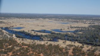
Our final wetland system for the data was the Hattah-Kulkyne Lakes, one of Victoria’s important wetland parks. After a long day’s flying, we had a surprise. This is an extensive, intricate system of channels floodplains and lakes. Most of the time there is a bit of water in the major lake and not much more – not today.
Surveying Hattah Lakes – with water everywhere in the channels
There was water everywhere. And so back and forth we went, making sure that we surveyed all the water there. There were moderate numbers of waterbirds and reasonable diversity. In some places, the cormorants were breeding.
Pelicans and cormorants flew up from the water where they were feeding in their hundreds, leaving ‘take off splashes’ behind
The lakes were obviously the beneficiaries of recent environmental water and it showed. There was a tremendous response. It was great to see the water flooding out so widely.
Widespread flooding on the Hattah Lakes floodplains.
