Date: Monday, November 12, 2018
Project: Eastern Australian Waterbird Survey
Observer: John Porter
This leg of aerial survey marks the last few days for 2018 – we head out of Sydney in clear weather for Moree and the Gwydir wetlands. Even though some light rain has fallen in the area recently, we are struck by the very dry conditions. As we pass over the fertile Liverpool plains many paddocks remain bare and ground cover of vegetation very sparse. After a quick stop at Moree we welcome aboard some local OEH water managers who are keen to monitor the location and effectiveness of recent environmental water release.
Farmland near Boggabri on the Liverpool plains was very dry (Photo: Terry Korn)
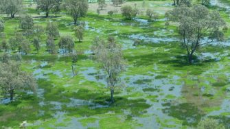
The Gwydir wetlands are a series of waterways, rivers and floodplains flowing west from Moree and eventually into the Darling. We find much needed flows of water have recharged billabongs and pools and flooded low lying areas to create brilliant emerald green wetlands on the Gwydir and Gingham watercourses, some with large concentrations of waterbirds. All thanks to environmental flows or “community” water purchased by the government and managed to benefit biodiversity, land holders and the local community.
Emerald green wetlands on the Gingham watercourse (Photo: Terry Korn)
Attracted by the newly flooded habitat we encounter good numbers of Grey teal, Black duck, Wood duck, Yellow billed spoonbill, Egrets, Brolgas, Glossy Ibis, Plumed whistle duck, pink eared ducks and migratory shorebirds. These wetlands are thriving with a diverse range of waterbirds present, thanks to their recharge with environmental water
Recently flooded wetlands on the Gingham watercourse (Photo: Terry Korn)
Recently flooded wetlands on the Gingham watercourse (Photo: Terry Korn)
As we move away from the Gwydir flood plains back over cropping lands on our return to Moree - we are again reminded of just how dry the surrounding landscapes have become
Dry crop lands (Photo: Terry Korn)
