Date: Monday, October 8, 2018
Project: Eastern Australian Waterbird Survey
Observers: Richard Kingsford
Overnight on Noonbah Station was a treat, just north of Survey Band 8 and on a tributary of the Thomson River. Their artificial wetland attracted reed warblers, Baillon’s crake and black-tailed native hens. It was also a magnet to a whole range of bush birds, including plum headed finches. Unfortunately, cane toads have now established here (about the last five years) in one of the driest parts of the country. As a result, mulga snakes and goannas seem to have suffered a serious decline, although goannas may be recovering. We waved goodbye to our hosts and headed west early in the morning.
From here, we flew west across dry river beds. The Diamantina River still held water in some of its waterholes and one of the deep waterholes we regularly surveyed but the waterbirds were thin on the water, just a couple of Pacific herons and pelicans.
And then we flew west to pick up King Creek which flows into Eyre Creek, which can flow down the eastern side of the Simpson Desert before joining the Diamantina River in Goyders Lagoon, south of Birdsville in a really big flood.
Eyre Creek had only a couple of tiny puddles of water. Even some of the waterholes which nearly always have water from groundwater were dry, near Bedourie.
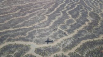
From here we decided to survey the two small lakes which are part of this system, Lake Koolivoo and Mipia. These are wonderful lakes which hold water much longer than the floodplain but they were drying. Lake Koolivoo was about 60% of its full surface area while Mipia was much smaller – only about 30% of its full size. There were beautiful crazy-paving channels cut into the dry floodplain, reflecting the last flood.
At last we had several thousand waterbirds to count. There were hundreds of whiskered terns, grey teal, wood ducks, pelicans and yellow-billed spoonbills. There were also about 30 brolgas. Lake Mipia was particularly shallow and so had hundreds of small waders and avocets. Lake Koolivoo was great to count.
From here, we headed for Birdsville to refuel us and the plane. And then south to pick up the Diamantina River again and Andrewilla Waterhole and other eastern waterholes. It was very tranquil flying along this stretch of water. The cloud had taken the heat out of the day and there was no wind. There were few waterbirds as usual, despite the stretch of water. These waterholes are really only home for darters, pied cormorants, pelicans and Pacific herons, with small flocks of hardhead.
We found a couple of claypans with water and hundreds of waterbirds, hardhead, wood ducks and black-tailed native hens. I even saw my first freckled duck – always a bit of thrill. This included a large flock of black-tailed native hens of hundreds on shallow waters drying back.
After all of our surveying, we had a quick break on a Diamantina claypan
Next was the other major river in the Lake Eyre Basin – Cooper Creek. It was just a string of waterholes, which were drying. There were just a few waterbirds, mostly fish eating birds scattered throughout the waterholes.
From here we bumped our way east, passing dry river after dry river, starting with Bulloo, then the Paroo and finally the Warrego before we finished at Charleville. We saw only a handful of waterbirds. Most of the many dams were less than half full with many empty – a stark reminder of the drought.
Charleville airport was the only oasis of green in this dry landscape - its lawns a magnet to grey kangaroos in front of our parked plane.
