Date: Monday, October 14, 2019
Project: Eastern Australian Waterbird Survey
Observers: Richard Kingsford & Peter Ewin
Pilot: Tim Dugan
Back on aerial survey after a year – there’s always a sense of anticipation about what the country and the rivers will look like. We know things are grim and so my expectations this year were not high. There is very little water but, as with any long term surveys, it was important to see how this year stacked up, compared to our past years. Today we headed west to Broken Hill from Sydney, out over the Blue Mountains. Our new survey crew on board was our pilot, me, Richard Kingsford, and Peter Ewin. Our first survey point was the northern part of Burrendong Dam where the Cudgegong River comes in from Mudgee. I visited Burrendong Dam on the ground in early September and we haven’t had much rain since. Today, it was only 4.3% full from filling in 2016, when there was more than two Sydney Harbours’ worth of water in this dam. The ‘arms’ of the dams were now just confined to the main channels, with the spillway high and dry.
A very low Burrendong Dam.
The spillway of Burrendong Dam, a long way from the water.
Burrendong Dam is the main river regulation structure on the Macquarie River, upstream of the Macquarie Marshes. I don’t remember it ever being as dry as it was today, during our 37 years of surveying it.
Surveying the northern arm of Burrendong dam.
From here, we surveyed about 10-20 kilometres of the Macquarie River. The main channels of the river still holds water although it has dried up further down, past the town of Warren. We don’t usually find many waterbirds along these rivers because the flowing water doesn’t provide that much food. But, this was one of the few areas of water around and so there were larger numbers of black duck and wood ducks than usual, as well as the odd little pied cormorant. A quick break to refuel in Dubbo and then we were on our way west again. This leg started with a whole series of small and sometimes reasonably sized farm dams. Not unexpectedly, many were dry, just reinforcing the impact of the current terrible drought. These dams often provide some habitat for wood ducks, herons and a few other ducks.
One of the large dry dams.
Some dams had some water, critical for livestock.
There was sign of some clearing of native vegetation, as we headed west.
There was very little water in this landscape. We eventually reached Menindee Lakes, site of the massive fish kills in January this year and late last year. Thin channels, slightly tinged with the green of blue-green algae, snaked their way upstream of the Main Weir, all that remained of the water usually contained within the large Lake Wetherill, a constructed dam.
Surveying along the Darling River where the water usually backs up and then fills the Menindee Lakes.
When the Menindee lakes have water, they stretch across the landscape in every direction, glistening in the landscape. Today there was virtually no water. Lake Pamamaroo was dry, with little sign of any dead fish that we had heard about this morning on the news.
The dry lake bed of Lake Pamamaroo.
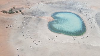
The only water in Menindee Lakes was left in Copi Hollow, a small lake connecting Lake Pamamaroo and Lake Menindee, but today only about 60% full in surface area. It had more waterbirds than anywhere else that we had surveyed today, including pelicans, cormorants, black duck, grey teal and a few pink-eared duck. From here we headed down towards Kinchega National Park, past a dry Lake Menindee, Lake Cawndilla and Emu Lake to follow the Darling River down for about 20kms. The river was now just a string of very small shallow waterholes in a dry river bed. Fish populations will struggle to survive in these waterholes through the summer, preyed on by the few cormorants and pelicans, and evaporation. It’s hard to see how much of this river will have water after the summer.
The Darling River.
