Date: Thursday, October 21, 2021
Project: Eastern Australian Waterbird Survey
Observers: Richard Kingsford & John Porter
Pilot: James Barkell
We got away early in the morning because we knew we had a fairly long survey leg. We flew north towards the Murrumbidgee River and the Lowbidgee floodplains and its lakes. We had been there the week before but then the conditions weren't great for surveying, so we hadn't been able to complete our surveys of some of the lakes.
We started with Yanga Lake, part of Yanga National Park. The lake had flooded into its southern parts, underneath the trees. It was very full. Like many of the wetlands we had been surveying, particularly the large lakes, there were very few waterbirds and only in among the flooded trees in the southern part.
We had surveyed Paika Lake last week.
Flooded areas on the western side of the Murrumbidgee River.
From here we went north, just west of the Murrumbidgee River, where water had spilt out on to the floodplain. Where the water was shallow and clear, there was plenty of aquatic vegetation growing and hundreds of waterbirds. High wetland productivity.
There were sizeable flocks of grey teal, pink-eared ducks, swans and coot.
Floodplains of the Murrumbidgee River north of Balranald.
Then it was north up to the Great Cumbung Swamp. We had thought that there might be more flooding across this magnificent wetland but it was primarily confined to the main channels with some flooding on other side up the reedbeds.
There were reasonable numbers of ibis, cormorants, herons and various duck species including black duck, grey teal and hardhead.
Great Cumbung Swamp and adjacent wetlands.
From here we headed northwest to survey the creek systems of the Booligal Creek system. This really is an amazing intricate network of channels and wetlands.
Complex Merowie Creek system.
It wasn't a big flood but still there were lots of waterbirds here, contrasting so many of the other places we had surveyed. Even so, there weren’t as many waterbirds as last year when there was more flooding and it was outstanding.
But it certainly showed the importance and capacity of this wetland system for waterbirds. We surveyed Merowie Creek from south to north and then down the Merrimajeel Creek system, picking up the various swamps and lakes as we went. There were lots of ibis, pied stilts in their hundreds which was very unusual, terns and hundreds of grey teal, black duck and pink-eared duck.
Black swans were breeding on some of the lakes. The combination of highly productive floodplains and shallow water makes for a great biodiversity response in these systems. One of the great concerns for these wonderful wetland systems is the damage that the enlarged Wyangala Dam will do. There is a plan by governments to double the size and capacity of the Wyangala Dam, which means that many of these floods will no longer happen on the Lachlan’s floodplains, as they are caught and stored by the dam upstream. This is the largely silent environmental and social cost of large dams. They destroy downstream biodiversity and these great sights will be no more, including the incredible colonies of straw-necked ibis that breed on these floodplains in large floods. It will be a tragedy for this magnificent Booligal Creek system, the Great Cumbung Swamp and Lake Cowal which we surveyed last week.
It is clear from all of the work in Australia and around the world that when we build these large dams and capture the life-giving floodwaters that goes down into these wetlands, you basically kill off their biodiversity. Not only that you're knocking out people’s livelihoods who rely on these floods for grazing their livestock. The dam will just mean a transfer of wealth upstream. And of course, there is very little focus on the biodiversity that's dependent on this great river system. Even the current Wyangala Dam has already brought considerable damage to this great wetland system.
We headed for Griffith to refuel and then surveyed a few wetlands on the way back, including Fivebough Swamp. This is a Ramsar-listed wetlands near Leeton, which relies primarily on managed flows. It was probably only about 30 or 40% full, with very few waterbirds.
We then surveyed a few farm dams up until we reached Temora when we needed to head back to Sydney. We will pick up the rest of the survey band next week.
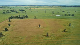
Surveying farm dams east of Temora.
By Richard Kingsford
