Date: Monday, November 22, 2021
Project: Eastern Australian Waterbird Survey
Observers: Richard Kingsford & John Porter
Pilot: Tim Dugan
This Mount Isa to Rockhampton leg is always one of our most taxing. It starts with a half hour flight south to the beginning of Band 9, on the Georgina River at Roxby Downs and then all the way through to north of Rockhampton.
So we always get away early. It was up at 4 a.m. for a start before sunrise, in the dark.
We arrived in perfect time for the first survey, as the sun was coming up in the east. And it was onto the permanent waterholes along the Georgina River including Lake Katherine. Sometimes these have lots of waterbirds, particularly cormorants. But there were relatively few this year, probably because there's a fair bit of wetland habitat around.
Surveying Lake Katherine on the Georgina River.
This year, there had obviously been quite a lot of local rain here given bright green growth along all of the creeks.
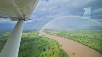
Water creates ‘green fingers’ of vegetation along the creeks.
Most of the creeks around here, which are almost always dry, had water –very brown from recent runoff.
Despite the water in the creeks, there were very few waterbirds. The waterbirds like standing water in wetlands, like lakes and swamps.
As we went west today, we saw the true capriciousness of rain. Here in the west, the cattle were fat on green grass everywhere but it soon got worse.
There was water in many of the channels of the Diamantina River.
As we got towards Winton and Longreach, it got much drier although the Thomson River, which flows past Longreach, and had water in its channels. We landed at Longreach after a very long stretch of five and quarter hours. Normally we stop at Winton but there was no fuel there today.
Thomson River channels.
And then further east of Longreach, wet again, before very dry north of Rockhampton. There were winners and losers for graziers all along our west to east flight path today.
After surveying a few small farm dams and creeks, we headed for the big waterbird habitat areas, including Lake Dunn and Lake Galilee. Lake Dunn is the freshwater Lake which was full and had up to a hundred waterbirds with plenty of diversity. These freshwater lakes aren’t nearly as productive as the salt lakes.
Surveying Lake Dunn.
After this, it's always with great anticipation that we head off to survey Lake Galilee. It is one of the ‘magic wetlands’ of Australia. When it's got water there are tens of thousands of waterbirds because the salt clears the water, allowing vegetation to grow. It's a highly productive wetlands system. We started on the western end but all of this was dry. Luckily, there was some area flooded on its eastern areas and, true to form, it had hundreds of grey teal, pink-eared ducks, avocet, cormorants and black swans.
Surveying Lake Galilee.
Our observer team (John and Richard), during a quick break at Lake Galilee.
As we headed east, we soon came across another area that had caught the rain, with many of the dams full. They all had a few grey teal, black duck and the odd brolga pair.
Surveying one of the lagoons in the area.
We hit another very dry area, north of Rockhampton, after we had flown over a coal mine. This matched our observations a few days earlier on the Styx River, further to the east on this survey band, which we had surveyed a few days earlier.
Coal mine north of Rockhampton.
Here there were a few lagoons with water and farm dams.
Surveying one of the lagoons.
This is an area where we've seen hundreds of brolgas in the past. But today they were only a few small flocks on some of the dams.
Surveying an almost dry dam as the weather closed in on us.
The weather was grim with thunderstorms all around towards the end of the day. Rockhampton, where we were heading for the night, had been hit by a hail storm but luckily it looked like most of the bad weather was passing to the east.
Flying into Rockhampton.
By Richard Kingsford
