Date: Tuesday, October 25, 2016
Project: Eastern Australian Waterbird Survey
Observer - Richard Kingsford
We left early on a crisp morning, flying over the crater lake, Tower Hill Nature Reserve, near Warrnambool on our way to the eastern end of Band 1 where we finished off surveying the few remaining wetlands near Port Fairy.
Tower Hill Nature Reserve, a crater lake
It was a slow trip north of over 200 km to pick up the eastern end of Band 2, just north of the South Australian town of Kingston. A forty-two knot headwind slowed us down by about forty percent of our normal speed. So much so, that we had to refuel at Narracoorte in South Australia, overflying one of the more important wetlands in South Australia, Bool Lagoon. Like most large wetlands, it was sprinkled with nesting birds, including swans, ibis and egrets.
Bool Lagoon, one of the largest freshwater lagoons in South Australia
We start surveying the saline lagoons which are a continuation of the Coorong, which stretches south from the mouth of the River Murray. This part of survey band 2 always involves flying north and surveying wetlands the entire 30 km of the width of the survey band and then we hop over the dunes and there is another north south string of wetlands.
Surveying the saline lagoons north of Kingston
Saline lagoons run north south, just east of the coast of South Australia
The wetlands of the lower southeast of South Australia run on the eastern side of the old north-south hills. There was much water than any of us can remember in this part of the world.
Surveying Tilley Swamp in the lower southeast wetland system of South Australia
The wetlands nestled in among the dunes of this system are among the more productive on the eastern Australian aerial survey in terms of the numbers of species and their counts. Not today. As elsewhere, the waterbirds were thin on the water. There were pairs of many waterbirds and nests and broods of swans and broods of Australian shelduck.
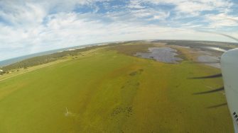
Surveying freshwater wetlands in the lower southeast wetland system of South Australia
Freshwater wetlands in the lower southeast of South Australia, near the coast
Many of the wetland degraded by large drains, aimed to reduce flooding. The water is taken out to sea, and used for grazing.
Large drains degrade the wetlands of the lower southeast of South Australia
In some parts of this region, water is obviously held for too long and the swamps no longer dry out the way they used to. This kills large areas of trees which become water logged.
Water logged trees in the lower south east wetland area.
This is always a taxing part of the survey because we have to change and turn across lots of wetlands. It is also sometimes difficult to navigate, particularly when there are so many wetlands. Once through the southeast wetland area, we have some relief without many wetlands as we fly over the mallee, near the town of Bordertown. In addition, there are increasing number of feral deer in the region.
Deer in the lower southeast wetlands
We pass over the mallee of the Little Desert National Park, surveying small lagoons which in most years have no water but not this year. Then we come into a patchwork of wetlands around the Wimmera River. This includes the distinctive pink lake, a colour which comes from microscopic algae.
Pink Lake near the town of Dimboola
The Wimmera River very seldom flows but the floods earlier this year left water on its small floodplain. We were busy. Many of the saline wetlands around Horsham, which are usually dry were flooded. They still didn’t have many waterbirds. We refuelled at Horsham and had a break.
Much of the area between Horsham and Wangaratta is farmland with just farm dams and the odd river criss-crossing. We survey the main rivers as we go east: the Avoca, Loddon and Campaspe. There are small clusters of wetlands on these rivers.
Surveying freshwater wetlands on the Avoca River
There is seldom little more than the odd wood duck or pelican on these rivers. Once past the Campaspe River, we reached the Wallenjoe wetland system in the Goulburn-Broken catchment. This is one of the most impressive wetland systems in the Murray-Darling Basin but it has been many years since it was comprehensive flooded the way it was today. Even so, not all the wetlands were flooded which was surprising.
Wetlands in the Wallenjoe system
The main lakes all had water and importantly many of the ephemeral swamps were also inundated. These were the most productive in the system, with many swan nests. The main lakes are regulated now to hold water for later release for irrigation. Because of this, their productivity for waterbirds in these parts of the wetland system are low. The swamps were a considerable contrast, with a higher diversity and higher numbers. Once we had got through this wetland system, we were left with only two major wetlands: Waranga Basin and Lake Mokoan. Waranga Basin is essentially a large dam. We have seldom surveyed many waterbirds here. Even though the sides of the dam are not steep, it just doesn’t have much productivity and so few waterbirds of any sort.
Lake Mokoan, also known as the Winton wetlands, was once predominantly a storage dam but now a focus on wetland rehabilitation has dried it out over the last few years. I was looking forward to seeing it full after so long without water. It was only about sixty percent full with its dead trees a stark reminder to a wetland that was flooded permanently, killing the trees.
Lake Mokoan or Winton wetlands near Benalla.
We reached Wangaratta after a long day of surveying with so much water around.
