Date: Friday, October 7, 2016
Project: Eastern Australian Waterbird Survey
Observer: Richard Kingsford
Today’s survey from Mt Isa to Rockhampton is a long day. We start early in the relative cool, hoping that we wont have a head wind. Makes for a much slower run. As Mt Isa lies at the most westerly point on Band 10, we have to head south to pick up the beginning of Band 7, at the top of the Lake Eyre Basin in the Georgina River catchment. The country looks like I have never seen it, cloaked in a light green blanket, with its wriggling creeks and rivers. This area usually gets summer rainfall from the tropics and so this year is unusual. Our Mt Isa taxi driver told us that September had been the wettest on record.
The green tinge across the landscape, at the top of the creeks of the Georgina River catchment in the Lake Eyre Basin
Survey Band 7 starts on the long waterholes of the Georgina River. The water is much ‘muddier’ looking than I have seen it before, following the recent floods. Every survey is different – it is a great privilege to survey so much of the continent each year. Sometimes these waterholes can have hundreds of waterbirds, but not today. Just the odd small flock of pelicans. More of the same expected pattern.
Surveying the waterholes of the Georgina River in the top of the Lake Eyre Basin catchment.
Everywhere different hues of green the plethora of plant species that have responded with a flush of growth from the tremendous September rains. People out here are saying they haven’t experienced a season like this since the 1970s, when winter/ spring rainfall was followed by big summer floods. With the soil saturated and many of the waterholes filled, any more substantial rain will pour down the rivers and perhaps on to Lake Eyre. This happened in 2010 and 2011 but even those rains didn’t really fully fill Lake Eyre which hasn’t been full since the 1970s.
Cattle watering on the unusually green plains
Channels weave through the green landscape to join the rivers of the Lake Eyre Basin
Next is the mighty Diamantina River which is a braided network of channels in this part of its course. Plenty of water shows where the floods have left their mark, pushing water down towards Lake Eyre.
Surveying the channels along the Diamantina (excuse the insect splotch half way through)
Lunch at Winton where the easterly wind has picked up and so it will be slow heading east. At 30 degrees, the inside of the plane feels like a warm oven. The country continues to look stunning as we head east.
A small herd of camels as we pass by
The rains don’t seem to have produced as much runoff as I expected which means some of the lakes haven’t filled as much as the country would indicate. Lake Dunn, a freshwater lake near Aramac, often fills with local rainfall but is only about sixty percent full.
Lake Dunn was not completely full
It’s not long before we reach one of my favourite wetlands in Australia, Lake Galilee. This is a stunning salt lake and when it is full of water it has tens of thousands of waterbirds with probably as many thirty or forty species.
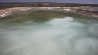
Lake Galilee was only about 20% full but is still the most productive wetland for waterbirds that we have seen in our four days of flying.
The rains obviously haven’t been sufficient to fill the lake which has only shallow areas separated across different parts of its size. There are still hundreds of black swans, migratory shorebirds, red-necked avocets and a few brolgas.
Surveying Lake Galilee, north of Aramac, one of Australia’s most important waterbird sites.
We soon leave the Lake Eyre Basin behind and head over the hills of the Great Dividing Range, across a string of large coal mines before reaching the pastoral and crop country north of Rockhampton. Dams and lagoons lie in between large cropped areas and cleared pastoral country. This is the best brolga spot on the whole of our survey. The birds must collect here and feed on left over grain because there can be a very small amount of water with hundreds of these majestic animals sauntering around the edges.
Up to a thousand brolgas on a small puddle of water north of Rockhampton
We eventually finish just before the hills, beyond which was the Styx River which we surveyed two days ago as we went up the coast and then headed for Rockhampton where we have a day off (a regulation for the pilot). We will be heading west to the channel country on Sunday.
