Date: Friday, October 13, 2017
Project: Eastern Australian Waterbird Survey
The last day of the survey and after 11 days in the light aircraft I am looking forward to some home comforts and routine. There was excitement upon leaving a greening Armidale for Band 4 to an even greener Upper Hunter. This is an interesting task with the opportunity to see parts of eastern Australia few have the privilege of experiencing in their life time.
Low cloud is a hazard we often encounter. Photo: Terry Korn
Low cloud just south of Armidale prevented us from counting our last wetland in Band 5, but the flight to the water storage beside Liddell Power Station, the first wetland in Band 4, took us over stunning country in the Barrington Tops region. This is the sight of Australia’s only unsolved aircraft disaster when a Cessna 210 which went down in a storm with two on board. It has never been found despite extensive repeated searches.
Fertile river flats neat Liddell Power Station. Photo: Terry Korn
Open cut coal mines greeted us as we got closer to Liddell as did many hazards such as towers and electricity transmission lines. It was difficult work for the pilot to navigate the area and safely get us to the Hunter River which we also survey. Neither the Liddell Lake nor the Hunter River ever yield many birds but the accumulated data of 36 years tells a story about use of these systems by birds in this fertile valley.
Taking coal to Newcastle (coal loading facility). Photo: Terry Korn
We then headed to Myall lakes to complete the coastal section of Band 4 which we were prevented by bad weather from doing on the first day of the survey. This is always a tricky area to fly because of the military restrictions surrounding Williamtown Air base. Special requests have to be made by the pilot at multiple points to ensure we have access to the low level air space we need for the survey. Sometimes we are refused entry to the area because of military (air force) activity. Today we negotiate time and space so are able to enter at Smiths Lake, fly south over the lake complex and down the Karuah River to just north of Hawks Nest. Perfect flying conditions allowed us to marvel at the beauty of this area. Glassy waters were dotted with hundreds of Black swans, cormorants, pelicans and the occasional Black and Chestnut Teal duck as we wound our way along the seaward shore of the lakes.
River estuaries offer prime habitat for waders. Photo: Terry Korn
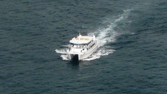
With instructions to fly seaward after completing the count we were lucky to see whales migrating south as we passed the entrance to Port Stephens. A whale watching boat was leaving the Bay heading north, oblivious to the fact that three whales were less than one kilometre away off Zenith Beach to the south. We always enjoy whale spotting and get a feeling of satisfaction knowing the humpbacks have made such a good population recovery over the last few decades. They fascinate us each time we fly the coast.
Whale watching is popular at Port Stephens. Photo: Terry Korn
A 30 minute run had us at Bankstown before lunch. I was pleased to punch into my phone the words “landed Bankstown” to the Search and Rescue duty officer. Survey completed-11 days, thousands of kilometres, 9 beds and 44 take-off and landings!
