Date: Tuesday, October 9, 2018
Project: Eastern Australian Waterbird Survey
Observers: Richard Kingsford
Today we surveyed a particularly dry stretch on a dry continent. There was very little water between Charleville and Kingaroy and then from Goondiwindi to Cunnaumulla along Survey Band 7 going east and then back west along Band 6, heading for Lake Eyre if it had water which it hasnt.
Most of the day was spent surveying small and large dams. There were plenty of small dams between Charleville and Kingaroy. Most had small flocks of ducks and other waterbirds but many of them were also dry.
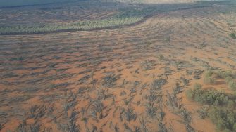
Along the way east of Charleville, this landscape is changing rapidly, with increasing area of fairly recent land clearing.
Even the weir at town of Mitchell had low water levels. The waterbirds are surprisingly not on these reasonably large bodies of water. This probably relates to their lack of productivity, even greater in small farm dams that are drying and shallow for the waterbirds to feed.
Once we reached Kingaroy, everything was greener. Obviously there had been a reasonably recent bit of rain through here. The large Gordonbrook Dam and the swamp on the top of the hill near Kingaroy had water. The swamp is often dry but today it had water and there were hundreds of teal and black duck, even though it was only half full. Gordonbrook Dam also had hundreds of waterbirds, mostly fish eating birds but also black duck, grey teal and hardhead.
Our last dam was the massive Bjelke-Petersen, named after the former premier of Queensland who originated from Kingaroy. The dam was a shadow of its former water glory, with hardly any water where we usually survey, except for the original creek line. It is currently only 15% full, the lowest I have seen it since we have been surveying it. There were still hundreds of waterbirds, mainly wood duck and grey teal. The dam was the last part of the survey along Band 7, which had started the day before, south of Birdsville.
We refuelled at Dalby and then headed south to pick up Band 5. We had surveyed this on the eastern side of the Great Dividing Range on the Bellinger River. Seems ages ago. First up was the large Coolamunda Dam on a tributary of the Macintyre River. Another large dam that was at its lowest point, compared to all of our previous surveys, only 29% full. The plus on the waterbird front was that this had exposed lots of shallow areas and there were more than a thousand waterbirds of many different species, from migratory shorebirds to pelicans. It was also one of the few areas of water around. There were also hundreds of teal and pink-eared ducks.
And then we kept heading west across the cotton country of the Border Rivers, including the Macintyre River. In an average year, we need to criss-cross from large off-river storage to large off-river storage but many were dry this year. Those that had water tended to be shallow and good for a range of waterbirds, sometimes up to a hundred. The few that were full, had hardly any waterbirds, a common pattern for these dams, because the water was just too deep.
We needed to refuel at St George because we weren’t sure whether there would be fuel at Cunnamulla where we were overnighting. From here, we flew down the Condamine River which supplies the Lower Balonne floodplain which has been significantly affected by the diversion of water for cotton irrigation around Dirranbandi, including Cubbie Station. We recently published a paper on the severe negative impacts of these developments on the breeding of waterbirds on Narran Lakes, a wetland listed as internationally important under the Ramsar Convention and one of the more important breeding hotspots for ibis in Australia, particularly straw-necked ibis. This is symptomatic of the major ecological problems experienced by rivers, wetlands and the dependent plants, animals and other organism on rivers when large amounts of water are diverted.
We left this cotton country and headed west to Cunnamulla. There were only a few dry wetlands along the way. We also surveyed a large, mostly dry storage, south of Cunnamulla where water is diverted from the Warrego River for irrigation. This is a relatively recent development which seems to be growing. There are also irrigation developments further north on the Warrego River but it is not a severely impacted river system like others in the Murray-Darling Basin. We spent the night in Cunnamulla.
