Date: Monday, November 4, 2019
Project: Eastern Australian Waterbird Survey
Observers: Richard Kingsford & John Porter
Pilot: Tim Dugan
We left Sydney and headed northwest to the Macquarie Marshes. We weren’t expecting to see many waterbirds, given that we had seen only four a couple of weeks ago when we surveyed the northern part of the Macquarie Marshes, which covers about a third of the Marshes, during our survey as part of the Eastern Australian Waterbird Survey. We were keen to find out if there was much water around after the rain on Sunday. We actually had to check whether we could survey the area because there was widespread fog, west of Dubbo, which had lifted by the time we arrived. The Macquarie Marshes is very dry. I haven’t seen it this dry in all the time I have been coming out here on the ground and in the air, since about 1986.
During our survey of the Marshes, we flew 11 east to west transects, each marking out a two hundred metre swathe on the ground. We count all the waterbirds on either side of the plane within this boundary. During floods there are thousands of birds counted within these transects which stretch, north to south, over the eighty to a hundred kilometres of the Macquarie Marshes.
In an hour of surveying, we saw one black duck. There is only the odd farm dam with water in this magnificent wetland. This year not even an environmental flow provided water for the animals and plants. The floodplain graziers are also struggling with the drought. It was some relief to hear that they had got 37mm of rain overnight here. In a few places in the Macquarie Marshes, you could see puddles of water but not nearly enough to really help the Marshes really recover. To do so, they really need a lot of water coming from the catchment upstream.
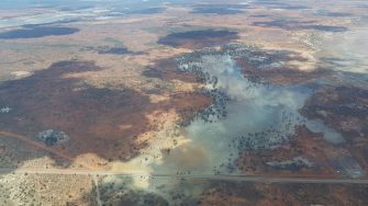
We flew over the recent fire which had devastated the northern reedbed in the Macquarie Marshes. Fires are reasonably frequent in this reedbed but worryingly becoming more frequent and probably doing more damage. In the past the root zones of the plants would have been much wetter than they are today. The drying out of the Marshes as a result of reductions in flow diverted away upstream are probably making the reedbeds more vulnerable to long-term damage.
From here we headed north, along the Darling River, to Bourke to refuel. The significant rain of 60-95mm the previous day was lying around in puddles everywhere.
After we had refuelled, we headed northwest to survey Yantabulla Swamp on Cuttaburra Creek which flows between the Warrego River and Paroo River, which supplies water to our other site Currawinya Lakes in southwestern Queensland. There was no more than a ‘puddle’ of water in Yantabulla Swamp, despite the rain. It also heavily relies on river flows down the Warrego River from southwestern Queensland. Local rainfall rarely makes a big difference.
The Currawinya Lakes within the National Park were also virtually dry. There was a small puddle on Lake Numalla with only a few avocets. It was very disappointing for a lake system which I surveyed in the late 1980s and held hundreds of thousands of waterbirds regularly.
We returned to overnight in Bourke.
