Date: Tuesday, November 5, 2019
Project: Eastern Australian Waterbird Survey
Observers: Richard Kingsford & John Porter
Pilot: Tim Dugan
We’ve headed out early for a dawn departure because of the forecasted gusty south westerly winds, heading east from Bourke to the Gwydir wetlands. The puddles around Bourke’s dump of rain soon dried up as we headed east, showing how patchy the rain was over the weekend.
We flew past a dry Narran Lake system (including Narran Lake Nature Reserve) to the north. In times of flood, it is a magnificent wetland, supporting huge numbers of waterbirds and breeding colonies of ibis, spoonbills, cormorant and heron.
Narran Lake looking north
Once we got to the southern part of the Gwydir, we headed along the Meehi River and Mallowa Creek system. There were just a few waterholes with black ducks in, with unusually high numbers of terns along the western part of the Mallowa Creek.
The day after we arrived, there was a release of environmental flow into the Mallowa Creek system which was very dry. These small environmental flows play a critical part in providing some refuge for fish, turtles and vegetation in extreme drought, trying to ensure they make it through.
A series of waterholes right at the end of the Gwydir river system are usually full of water but today were much drier than normal. Even these patches of water had few waterbirds, reflecting the predominant pattern of our surveys.
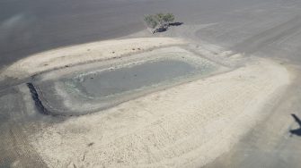
As in other parts of the Murray-Darling Basin, even the stock dams and off-river storage are nearly all dry. Most of the large water storages in Gwydir area are dry.
We then moved onto the main Gwydir wetlands and watercourse and the Gwydir wetlands, a series of channels, floodplains, waterholes and terminal deltas distributed along the Gingham watercourse and Gwydir system. Once again we came across another Murray-Darling Basin wetland that is extensive in floods but now with hardly any water. This wetland looks very grim.
Some parts of this wetland form part of an internationally significant Ramsar site that covers 823 ha. When filled, these wetlands provide important breeding and feeding habitat for a highly diverse waterbird community, including endangered species such as the Australasian bittern and Australian painted snipe. Today however it’s a different story and most of the sites within the Gwydir are dry or almost dry and there are few waterbirds to be seen and no breeding. Later in the day, our Moree taxi driver got onto the demise of these magnificent wetlands – ‘once like the Florida Everglades’. He used to go hunting in them as a kid, when there ‘were clouds of ducks’ and enough ‘black snakes, strung end to end, to get you to the moon’. But as he said – ‘the development of the river has killed much of it off’.
We weave back and forth across the floodplains. They are dry, with large black areas showing where a recent fire had burnt the reed beds. Patches of green showed a response to recent rain but there was no water.
We hunt for water and birds – eventually finding some. There were about 300 black duck and grey teal, huddled together on a tiny farm dam, all the water remaining. It was indicative of the poor state of wetlands and their waterbirds. We moved on to survey the Gwydir River near what is locally known as the ‘raft’, a large patch of dead timber in the river. We noticed more die back of riparian flood dependent eucalypts, such as red gum and coolibah here, than we have seen in the past. Finally, we finished up surveying Yarraman Weir on the Gwydir River, as gusty winds had kicked up clouds of dust, making counting very unpleasant. It is clear the landscape is badly drought affected with only c. 95 mm rainfall this year – about one third of what had fallen by this time last year.
The next day we headed straight back to Sydney. The following week would finish up the survey along the Lachlan and Kerang Lakes.
