Date: Tuesday, November 23, 2021
Project: Eastern Australian Waterbird Survey
Observers: Richard Kingsford & John Porter
Pilot: Tim Dugan
An early start out of Rockhampton again – with a bright outlook for the day until we got closer to the hills. Then we saw the low heavy cloud over the Great Dividing Range. Luckily by the time we got to our first survey wetland, Callide Reservoir near the power station, the cloud in the hills was high.
Power station and Callide Reservoir.
Surveying Callide Reservoir
And the sun stayed with us for a couple of hours. We surveyed a series of farm dams and permanent lagoons around Biloela and Moura. There had obviously been a fair bit of rain through here but most of the dams were still only half full. Many of the dams had a few teal, wood duck and black duck. There were also swans, pelicans and pied stilts.
Surveying one of the larger dams
The lagoons seldom have any waterbirds, apart from occasional cormorants and black ducks. There were a couple of off-river storage which are deep and large dams. They did not have many waterbirds and only do so when drying down and there is shallow water to feed.
Surveying one of the lagoons.
Surveying an off-river storage.
On the way west, near Moura, we crossed over one of the large coalfields.
Just south of the town of Emerald, the clouds started getting lower and thicker. There was about half an hour where we were concerned we might have to go up and head west above the cloud but luckily the clouds lifted, allowing us to keep surveying. Even though it was very green around here, there had obviously been relatively little runoff. Most of the dams were not full and wetlands empty.
Surveying one of the large natural wetlands south of Rolleston, which was almost dry.
Around here, two of our previously surveyed wetlands, farm dams, had disappeared under developed coalfields. It was then over the Great Dividing Range and on to the western flowing rivers, starting with the Barcoo River which ran past Blackhall where we refuelled.
Surveying the Barcoo River, with recent rainfall.
The country around here looked tremendous, from recent rainfall and their floods and it wasn’t just the floodplains. We managed to have a quick break along Farrars Creek, a tributary of the Diamantina. The flowers were out; the birds were singing and there was lots of insect activity, including quite a few locusts.
Water in Farrars Creek main channel.
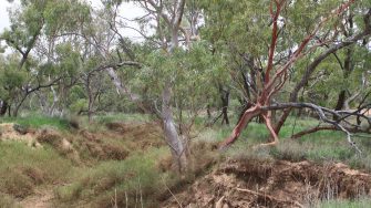
River red gums along the waterway.
River Lily.
Locust.
The Diamantina River was in a spectacular flood. Last time it looked like this was in 2016. There was so much water but very few waterbirds. But where we saw them, they were usually in pair, probably getting ready to breed. These floods have well and truly ‘primed’ the system for this La Nina year, with potential for future floods this year allowing for flooding right through the system.
Diamantina in flood.
Then it was on to the Eyre Creek system, including the two filled freshwater lakes, Lake Koolivoo and Lake Mipia. It was great to see a flood in full swing here – not a big flood but a minor to medium one. Lake Koolivoo was full but Lake Mipia was only about 70% full.
Flooded Lake Koolivoo.
Surveying Lake Mipia.
Neither of the lakes or any of the other flooded waters, creeks and clay pans around here had many waterbirds.
Surveying Eyre Creek.
Surveying between the dunes.
Lake Phillipi, further to the west, was also full from this flood. It’s a massive freshwater lake which had pink-eared duck, grey teal and pied stilts, but not in great numbers. The waterbirds were spread across the lake.
Finally, we finished up the survey on Band 8, on the two lakes filling from the Mulligan River. Lake Mumbleberry had about 70% of its land surface covered with water, while Lake Torquinie was only about 20% full. They were hundreds of grey teal and pink-eared ducks where the water was streaming in. After finishing, we went to Birdsville for fuel and isolated ourselves overnight for the next day.
By Richard Kingsford
