Date: Friday, October 17, 2014
Project: Eastern Australian Waterbird Survey
Observer: Richard Kingsford
The home leg. This was our easiest day, mopping up on ‘bits’ of survey band 4 which runs from south of Broken Hill at Menindee Lakes, through to Myall Lakes on the coast. The western part of Band 4 will be done in a couple of weeks by another survey team. Today, we ‘finished off’ the eastern section from the Macquarie River through to the Hunter River.
The Macquarie River meanders downstream of the town of Wellington through to Dubbo. Then eventually on to the Macquarie Marshes, which we surveyed yesterday. We surveyed east along the river. Like a lot of rivers in the upper reaches, the waterbirds were few waterbirds, just a handful of wood ducks.
Photo 1. The Macquarie River below Burrendong Dam, showing irrigated areas (circles) in this upper part of the river.
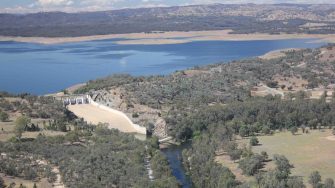
Burrendong Dam captures water in the Macquarie River, mainly for irrigation downstream, just east of Wellington. Like many regulated rivers in the Murray-Darling Basin this has impacted on downstream wetlands and landholders. For example, much of the water regulated by the Burrendong Dam used to go through to the Macquarie Marshes which are now at least 50% smaller than they used to be. Water levels were low in Burrendong Dam – where there were pelicans, cormorants and wood ducks.
Photo 2. Burrendong Dam with very low water levels.
We finished off the survey on the Hunter River with the odd black duck and white-faced heron.
Photo 3. Hunter River.
This eastern Australian aerial survey has six more days over the following two weeks. First the two most southerly survey bands in Victoria and South Australia will be flown next week. Then the two middle bands over the Riverina and western NSW, the following week. We are also surveying the River Murray and the large wetlands of the Murray-Darling Basin in the first week of November when I will write descriptions again.
Map of survey route, 17th of October 2014
