Date: Tuesday, October 14, 2014
Project: Eastern Australian Waterbird Survey
Observer: Richard Kingsford
Cool morning at 22oC – great for aerial survey. Quilpie, where we stayed last night, lies on the banks of the Bulloo, a sometimes forgotten river of the inland.
Photo 1. The Bulloo River runs west until it eventually floods swamps on the border of New South Wales and Queensland
Australia had 12 river basins, including the Murray-Darling Basin and Lake Eyre Basin and the Bulloo was wedged between the two until recently when it became part of the Lake Eyre Basin. A storm over the last week had filled the waterholes along the Bulloo.
Video – Counting the waterholes of the Bulloo River
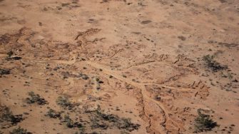
And then into the headwaters of the westerly rivers of the Murray-Darling Basin: the Paroo and then the Warrego. These are small rivers this far north, with no really useful waterbird habitat – that all happens downstream. We will get to the Paroo overflow lakes the day after tomorrow. Here – there were just patches of water.
Photo 2. Erosion patterns on the headwaters of the Paroo River
After the town of Charleville where we refuelled, we surveyed the patchwork of farm dams all the way to Kingaroy in southeastern Queensland, past Mitchell, Roma and Chinchilla. Once again most dams were empty or a quarter empty, reflecting the harshness of the dry spell. Here and there, they had a flock of wood ducks, grey teal, Pacific herons and pelicans.
Photo 3. Many of the farm dams around here had little water
Large dams with shallow margins, such as Bjelke Petersen Dam near Kingaroy have reasonably extensive shallow water areas where there are large numbers of pelicans and comorants as well as Pacific black duck and grey teal. After refuelling at Kingaroy, we pick up Band 6, 200km to the south.
This is the Macintyre River catchment. We started on Coolmunda Dam in the headwaters and then headed downstream to the west. The shallow margins of this dam which was only about half full provided habitats for grazing swans, cormorants, grey teal and black duck.
Photo 4. Coolmunda Dam had dried right back, providing grazing areas for flocks of black swans.
This Murray-Darling Basin catchment has undergone considerable water resource development, primarily for cotton. We surveyed the few remaining natural creek lines and spent most of the time surveying large off-river storages. Irrigation water is pumped into these from the river for later use. Their value for waterbirds is minimal, except occasionally for fish-eating birds such as pelicans and cormorants. They are generally too deep. Most were dry or shallow providing some habitat for waterbirds.
Photo 5. A large off-river storage with a small amount of stored water. At such times these dams provided habitat for a range of waterbirds but most of the time they are too deep.
We finished the day at St George – cool but windy and bumpy.
Map of aerial survey, 14th of October 2014
