Dr Mitchell Harley | Associate Professor Kristen Splinter | Professor Ian Turner
Protecting large-scale coastal environments

New tools and systems developed by UNSW students and researchers Dr. Mitchell Harley, Associate Professor Kristen Splinter and Professor Ian Turner are better analysing how Australian and international coastlines are changing, and what this means for the way we predict and manage coastal issues across the globe.
Ed Kearney performing a GPS survey and coastal erosion of Narrabeen Beach post storm in 2011. Photo credit: Professor Ian Turner.
After a case of intense coastal erosion in the Sydney suburb of Collaroy in 2016, Dr. Harley and A/Prof. Splinter created a range of tools and methods designed to better inform communities, residents, businesses and governments about the impacts of coastal erosion.
“We saw that storm coming many days in advance – we’re a bit like storm chasers in a way,” says Dr. Harley. “At the time, we mobilised with a whole range of coastal monitoring equipment to measure the site and obtain data before and after impact was made.”
The team even worked closely with UNSW Aviation, using their twin-engine aeroplane to help scan the coast. This allowed them to capture measurements of how the coastline was changing, quantify the impacts and apply this data to their future modelling systems.
Across the ocean
Following the 2016 event, PhD candidate Killian Vos created CoastSat, an open-source software toolkit that enables users to obtain a time-series of shoreline positions at any sandy coastline in the world.
Using 30 years of publicly available satellite imagery to capture large data sets beyond the local and regional scale, CoastSat collects information on past shoreline changes at locations where previously no measurements were available. “We are now at the forefront of leading new technology to measure beaches from satellites,” says A/Prof. Splinter. “So much so that the US Geological Survey is getting us to map the entire US coastline.”
While the team once individually surveyed single beaches, they’re now able to obtain data from any site using this new tool. “The US Geological Survey sees massive value in having those observations around,” adds A/Prof. Splinter. “We have a five-year project with them to do a variety of things within the coastal space.”
A/Prof. Splinter and Dr. Harley believe this tool has been a gamechanger in terms of what they are able to learn and achieve with these insights, and the global work it has enabled.
“I find it pretty amazing that the entire coastline of the US from east to west is being mapped right here in Sydney.”
- Dr. Harley
The CoastSat website provides an interactive platform to access satellite-derived shorelines obtained with CoastSat at beaches around the Pacific Rim, including Australia, California, Mexico and Hawaii. Example shown above is of Tweed River Entrance bypassing system in New South Wales, Australia.
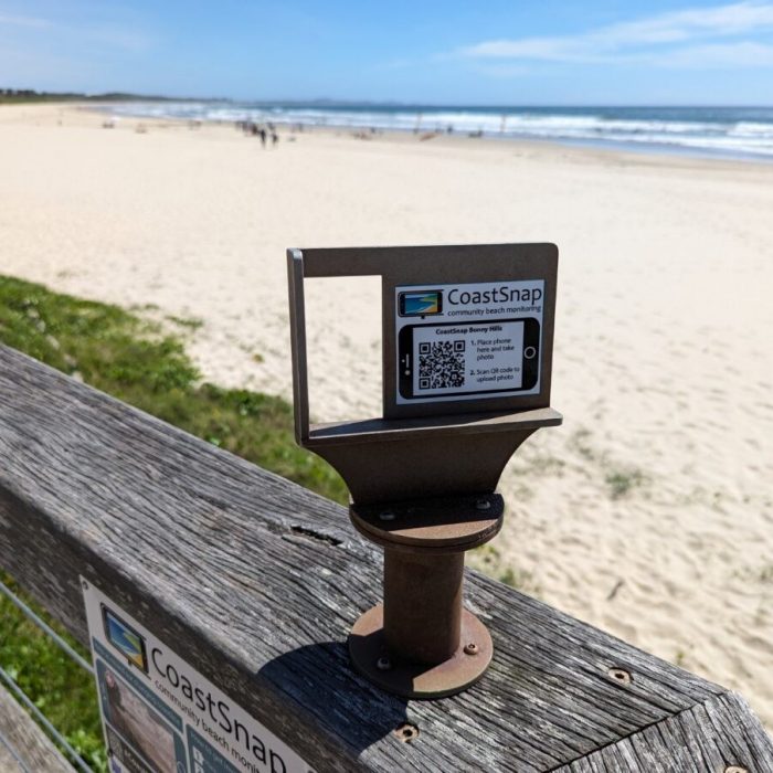
The very first CoastSnap camera cradle station was installed at Manly Beach on Sydney’s Northern Beaches on the 17 May, 2017. The CoastSnap App can be downloaded onto your smart device.
A picture says a thousand words
Dr. Harley has also been making waves with his local research. After recognising the strong emotional connection the community had to the coastline, he saw an opportunity to involve them in his research. “It led to this crowdsource kind of approach called CoastSnap,” he explains.
CoastSnap is a low-cost community beach monitoring technology that turns mobile phone photos into coastal monitoring devices in the hopes of mapping shoreline changes. “We’ve developed algorithms to use the photos people take and turn them into these mini satellite images, which allow us to track the shoreline.”
The team started by installing camera cradles on the beach, which people could place their phones into and take a snap. “They’re always at the same location, so it’s always the same photo,” adds Dr. Harley. “Over time we’ve gotten this incredible record of changes, all crowdsourced from the community.”
This joint collaboration between the UNSW Water Research Laboratory and the NSW Department of Planning, Industry and Environment first started in one location in 2017. CoastSnap is now live across 350 stations in 30 countries. “We’re doing really global-scale monitoring but it’s coming from local communities.”
Early warnings
Dr. Harley and the coastal team at UNSW’s Water Research Laboratory are also conducting research into the development of new systems for weather forecasting, which can indicate the risk for coastal erosion. “We’ve been working on ways to come up with something that gives 7-14 days advance notice when there’s a big storm on the way,” says Dr. Harley. “This allows for emergency management so people can be better prepared, take action and hopefully also prevent loss of life.”
Collaborating closely with Australia’s Bureau of Meteorology, as well as local and state governments, this research into better forecasting allows decision makers to better understand potential changes to coastlines as well as what might occur in the future.
As coastal erosion continues to be a significant issue for Australia and the world, Dr. Harley and A/Prof. Splinter hope their work can have an enduring outcome and impact. “A lot of challenges we’re dealing with now are legacy issues of poor decisions that were made decades ago, so it’s important we don’t pass on the burden to future generations,” says Dr. Harley.
“Hopefully our work will allow us to continue living, working and playing in the places that we love,” adds A/Prof. Splinter. “That can only come about through better understanding of how our coastlines are changing and insuring we plan accordingly.”
CoastSnap tracks how coastlines are changing through time – whether it be due to rising sea levels, extreme storms, or other factors.
Share this story
Water
Read more
Get in touch and see what’s possible.
Ask how we can help your business, industry, or market through collaboration.


